Why do earthquakes happen?
Earthquakes are mainly caused by movement in the Earth's crust. These events release enormous amounts of energy which has been built up over a long period of time. The seismic waves released cause the ground under our feet to shake and becme unstable. When two plates move against each other, it does not happen smoothly, ie they grind against each other. This can cause some of the rocks involved to become caught on one another, thus causeing them to bend. They eventually break because of all the pressure that is built up inside and an earthquake occurs. The place where the earthquake acually happens underground is called the focus of the earthquake, the area above, on the ground of the focus is known as the epicenter. Even after the earthquake, the Earth may have to readjust itself causing what people call aftershocks, damaging the surrounding areas even more.
Earthquakes are mainly caused by movement in the Earth's crust. These events release enormous amounts of energy which has been built up over a long period of time. The seismic waves released cause the ground under our feet to shake and becme unstable. When two plates move against each other, it does not happen smoothly, ie they grind against each other. This can cause some of the rocks involved to become caught on one another, thus causeing them to bend. They eventually break because of all the pressure that is built up inside and an earthquake occurs. The place where the earthquake acually happens underground is called the focus of the earthquake, the area above, on the ground of the focus is known as the epicenter. Even after the earthquake, the Earth may have to readjust itself causing what people call aftershocks, damaging the surrounding areas even more.
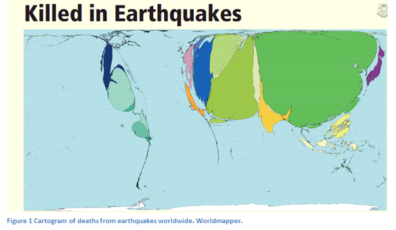
As this map shows, that the Asian and Middle Eastern regions of the globe have been blown up quite substantially, and are overly out of proportion according to the rest of the world, we can draw from this Cartogram Map that in these regions, citizens are at a high risk of being killed by an earthquake. According to this data, Italy on a global scale has a much lower percentage of earthquake related deaths.
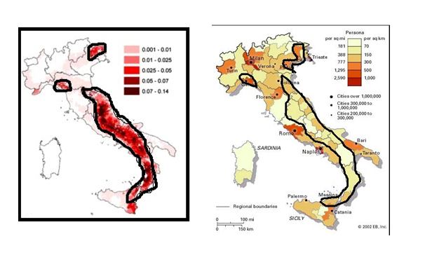
Map ‘A’ is a population density map of Italy showing the most populated areas per SQ KM. Map ‘B’ a choropleth map showing the seismic risk caused by Earthquakes. The black outlines on Map ‘A’ show the highest risk areas associated with the Seismic map ratings, as the black outlines on the population density map shows the same areas as map ’A’, there is a relation between the population and where these high risk earthquake zones are. We can draw from these graphs that citizens are highly affected by these earthquakes and that these earthquakes are affecting where the most populated areas are. Therefore, because of Italy being placed on top of the African and Eurasian this is what has caused this type of earthquake high risk line.
According to NASA studies, earthquakes are almost impossible to detect when and where they will occur. Earthquakes seem to strike out of the blue, but they are known to be building up energy for month’s even years before the strike. NASA is now investing in space satellites to help in the detection of earthquakes helping communities to prepare up to months in advance.
"One method is Interferometric-Synthetic Aperture Radar (InSAR). Basically, InSAR is when two radar images of a given tectonic area are combined in a process called data fusion, and any changes in ground motion at the surface may be detected." This method described by Jacob Yates a researcher at one of NASA’s flight centre. This technique has been proven to be accurate to as spot as little as 1mm ground movements per year, by watching these movements over the years they can spot where the high stress points are forming.
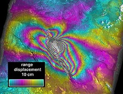
This is an InSAR image showing the shift height in the ground height.Scientist studied the feasibility of watching and forecasting the motions of the earth, occurring in the result of earthquakes from space. Determining the hazard level of the quake and sending out monthly hazard reports, based on the results. Just like whether forecasters giving percentage chances of rain, they would be able to do the same with earthquake high risk areas. This form of detection strategy will be very successful once put into full operation, when long terms studying of the shifts and motions have been observed this will be a very important step forward in the prevention of human deaths. For this to be worldwide effective, once NASA have done their initial testing and observing they have to make their satellites
and hazard reports available for all countries that are at high risk of danger.
and hazard reports available for all countries that are at high risk of danger.
